Friday, May 13, 2016
Friday, May 27, 2016
Hiked the South Piedra Lisa Trail — twice — so the video will be a compilation of those two hikes. Since doing this hike, I read that the new, lower section of the trail was completed in March, 2016. So a big thanks to all the volunteers who worked to make this happen. The new section is much more enjoyable than hiking up the gravel road. However, on the first hike, we completely missed the signs showing where the new section is located and just walked up the gravel road like we had done some years back. On the second hike, we finally got it right!
The South Piedra Lisa Trailhead and parking area is about 1/4 mile past the turnoff for the La Luz Trail. That 1/4 mile is over a gravel, washboard road so make sure your don’t have any loose fillings in your teeth. Like the La Luz Trail, unless you have a pass, there is a $3 fee to park at the Piedra Lisa Trailhead; however, there are no pay envelopes or a drop box at this trailhead. As I understand, you have to stop at the La Luz Trailhead to pay the fee. And there are no pit toilets at the Piedra Lisa trailhead, either, so, again, if you need those facilities, take care of that at the La Luz trailhead while you are there paying the parking fee.
The Piedra Lisa Trail is a really nice hike. If you get started early, most of the hike is in the shade. Keep in mind, the entire area east of the trail is closed from March 1st. until August 1st. because it is a raptor breeding area. As you follow the trail out of the parking lot, when you get to the gravel road, simply cross to the other side where a sign will direct you to the new section of the trail.
Elevation at the trailhead is 7,038 feet and it is a 2.2 mile hike up to the saddle. Elevation at the saddle is around 8,170 feet. From the saddle, a marker post indicates where the Piedra Lisa Trail continues down and on out to the North Piedra Lisa Trailhead, although the saddle is the typical turn-around point for the vast majority of hikers. Also from the saddle, the Rincon Spur Trail heads east towards the Knife Edge of the Shield.
However, if you turn around at the saddle and head back down, you will miss an ideal place to stop for a lunch break. Although you can’t see it from the saddle, about 500 feet to the east, off the Rincon Spur Trail, and another 100 feet in elevation gain, there is a gorgeous overlook that makes an ideal place to take a break and eat lunch before heading back down. Don’t miss it because the views are great! The video includes this part of the hike, showing how to get up to the overlook and back down to the saddle. Nothing to it, really, and well worth the short trip.
Elevation at the overlook is 8,272 feet. Total hiking round-trip was 4.6 miles. It took us 1.5 hours to get up to the overlook and another hour to get back down to the trailhead. Total climbing for this hike was just a few feet shy of 1,400 feet, at an average grade was 10%, and it is continuous climbing all the way to the top.
Click the map and elevation profile for a larger view. Then click the icons on the map for more information. If the icon notes come up empty, you will have to reload the map.
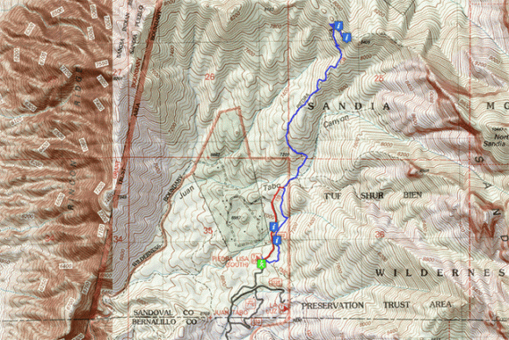
South Piedra Lisa Trail ~ Terrain Map / Trail Route
.

South Piedra Lisa Trail ~ Elevation Profile
To view the video full-screen, click to play, then click the 4-cornered square at the bottom-right of the player.
 June 1, 2016
 George

2 responses to “Day Hike: South Piedra Lisa Trail ~ Sandia Mountains ~ Albuquerque, New Mexico, USA”
bjregan
June 1st, 2016 at 14:45
I did that hike on May 14, and, like you, I found it much more pleasant to hike on the new section of the trail.
George
June 1st, 2016 at 20:12
I thought I saw you and Lee turn in to the La Luz that Friday morning, the 13th.
And, yes, that new section is definitely a keeper! 🙂